Case Study Israel
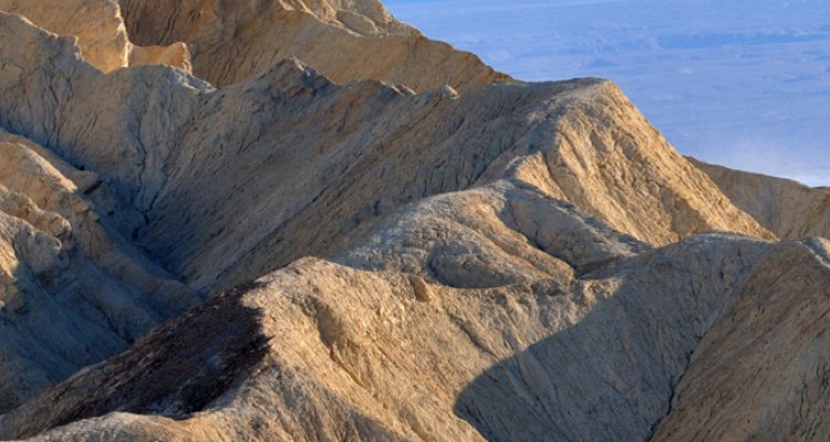
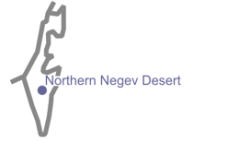
This PhD project (2003-2008) is focused on modelling landscape dynamics in semi-arid and arid catchments in the Northern Negev Desert of Israel.

The most relevant interactions and feedbacks among landscape structure, resource flows and organisms are related to water availability and redistribution. The position and amount of bedrock outcrops is very important for runoff production and water erosion. Vegetation influences redistribution of water and sediments strongly as well, increasing infiltration rate and stimulating sedimentation. On bare soils often surface crusts form, which reduce infiltration rate and increase runoff. Also digging animals can be important, by producing easy erodible soil and increasing soil porosity. The landscape dynamics in these catchments operate within boundaries set by climate and humans. The effect of climate change and human land use is studied as well.
» see Project Page for more information
LAPSUS Application
Firstly LAPSUS is adapted to a semi-arid and arid climate, whereby event based model runs are used instead of yearly model runs and dust deposition is included. Infiltration is calculated based on local run-on and soil depth. Secondly water redistribution was made surface cover dependent (vegetation or surface crusts). Thirdly, next to tillage erosion, the effect of intensive cattle grazing is included, which influences vegetation cover and therefore infiltration. Each adaptation of LAPSUS is tested in one or more semi-arid to arid catchments in the studied region, by actual and hypothetical simulations, sensitivity analysis and a 2800 year simulation. The resulting LAPSUS proves valuable for simulating landscape dynamics in the Northern Negev Desert, whereby both climate and human influence can be taken into account.
Results
I. Modelling dynamic water redistribution patternsIn arid climate regions redistribution of runoff water is highly relevant for vegetation development. The process of water redistribution at catchment scale is studied with the landscape process model LAPSUS, mainly used for erosion and sedimentation modelling. LAPSUS is modified to deal with the arid climate of the Negev Desert of Israel. The model is calibrated for two small catchments in the Negev Desert of Israel, Halluqim and Avdat. First, a sensitivity analysis of the modified LAPSUS was done. Especially pore volume appears to have a strong influence on the modelling results. Second, the capability of LAPSUS to deal with varying surface characteristics was assessed by comparing the water redistribution patterns in the two catchments with field data. Simulation results demonstrate that the catchments respond very different to precipitation. Water redistribution is larger in the dominantly bedrock covered Halluqim compared to the dominantly loess covered catchment of Avdat. Consequently, Halluqim has more positions with water accumulation than Avdat, and can sustain a larger vegetation cover including Mediterranean species. Finally the modelled infiltration patterns were compared with vegetation cover in the catchments. The results indicate that there is a broad agreement between infiltration and vegetation patterns, but locally there is a strong mismatch indicating that part of the involved processes are still missing in the model.
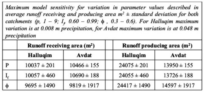
» Poster: Modelling dynamic water redistribution patterns in arid catchments in the Negev Desert of Israel
II. Modelling fluvial shrub mound formation and their stability on semi-arid slopesIn semi-arid areas vegetation is scarce and occurs often as individual shrubs on raised mounds. The formation process of these mounds is still debated. Shrub mounds are studied in the loess covered semi-arid catchment of Sayeret Shaked in the Northern Negev Desert. Height and diameter of shrub canopy and shrub mounds are measured and micro-morphological techniques are used to reconstruct the formation process of the shrub mounds.
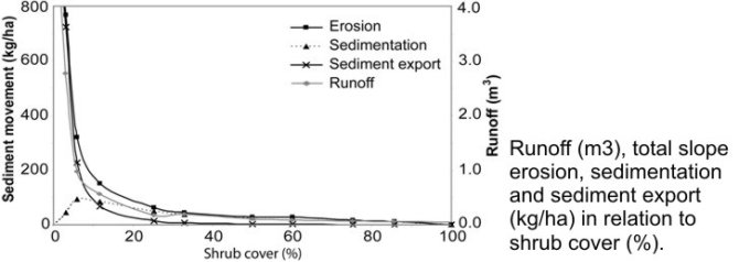
The results suggests that shrub mounds are formed by accumulation of atmospheric dust and sedimentation of eroded material in the vicinity of the shrub, as well as by erosion of the surrounding crust. Model simulations are done for single events and longer time scale (100 years). In the simulations mound formation appears most prominent at low shrub density and large shrub canopy diameter. Positive and negative feedbacks between shrubs and resource redistribution results in a meta-stable landscape. Long term model simulations of the current climate indicates that initially shrub mound formation rate is high, but stabilized at lower rates. In dryer and wetter climates mound formation is unlikely to happen, as respectively too little or too many resources are redistributed, causing a stable or highly erosive landscape. Mound simulation with LAPSUS is successful and resembles the actual shrub mounds in Sayeret Shaked. Consequently the model may prove to be valuable for the modelling of ecohydrological landscape processes in semi-arid areas.
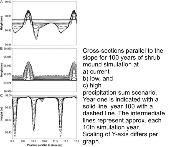
» Presentation: Modeling self organizing shrub mound formation and their stability on semi-arid slopes
III. Modelling Late Quaternary landscape evolution of Sayeret Shaked fluctuating between semi-arid to arid climate
No results are yet available.
Publications
- Buis, E. and Veldkamp, A., in press. Modelling dynamic water redistribution patterns in arid environments in the Negev Desert of Israel. Earth Surface Processes and Landforms. DOI: 10.1002/esp.1531.
- Buis, E., Veldkamp, A., Boeken, B., Jongmans, A.G., Schoorl, J.M. and Van Breemen, N., submitted. Modelling fluvial shrub mound formation and their stability on semi-arid slopes in the Negev Desert of Israel.
- Buis, E., Temme, A.J.A.M. and Veldkamp, A., in preparation. Model reconstruction of a Holocene valley fill in the Northern Negev Desert of Israel.
» more LAPSUS Publications.
Contact
Ir. Eke Buiseke.buis@wur.nl
+31 (0) 317 482038; Room B124, Gaia
Prof. Dr. Ir. A. VeldkampN. Van Breemen
B. Boeken