
News
ALOS-2 PALSAR-2 ScanSAR and Sentinel-1 data for timely tropical forest disturbance mapping: A case study for Sumatra, Indonesia
An article of Johannes Balling, Bart Slagter, Sietse van der Woude, Martin Herold, Johannes Reiche: ALOS-2 PALSAR-2 ScanSAR and Sentinel-1 data for timely tropical forest disturbance mapping: A case study for Sumatra, Indonesia, has been published in the International Journal of Applied Earth Observation and Geoinformation, Volume 132, August 2024.
Highlights
- ALOS-2 ScanSAR Level 2.2, the first freely available large-scale L-Band dataset, was assessed for tropical forest monitoring.
- We detected forest disturbances with L-Band ALOS-2 and C-Band Sentinel-1.
- Combined detections improved detection rates by up to 38 % and timeliness by 16.5 days.
- L-Band reduces C-Band omissions in disturbance events with tree remnants.
- L-Band detections are more accurate than operational ALOS-2 L-band alerts.
Abstract
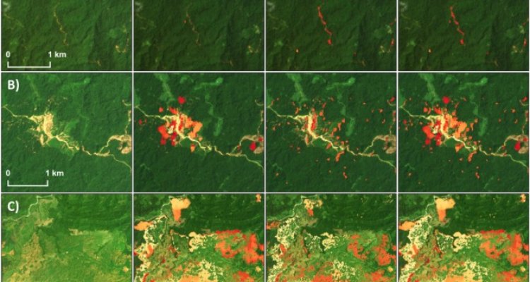
Precise and prompt information on forest disturbances in the tropics is critical to support law enforcement and protect tropical forests. In 2023, medium resolution ALOS-2 ScanSAR data (∼100 m spatial resolution) was made available for Southeast Asia, marking the first freely accessible large-area L-Band dataset. We assessed its potential for large-area forest disturbance mapping and its combination with high-resolution C-band Sentinel-1 data (∼20 m spatial resolution). We mapped forest disturbances in Sumatra, Indonesia for the year 2021 based on ALOS-2 ScanSAR data and Sentinel-1 data separately, and subsequently combined the mapped disturbances. Forest disturbances detected by both C-band and L-band SAR using a probabilistic change algorithm were combined at the product level by merging both sets of detections. The added benefit of combining both sensors was particularly evident in higher detection rates, as indicated by an improved producer accuracy (78.9 ± 11.9 %) compared to detections based on single sensor ALOS-2 ScanSAR (40.8 ± 6.3 %) and Sentinel-1 data (63.3 ± 9.6 %). Both combined and single sensor detections showed negligible false detections. ALOS-2 ScanSAR showed advantages for overcoming limited capability of Sentinel-1 to detect large-sized disturbance events characterized by post-disturbance tree remnants, occurring at locations with large-scale agricultural clearings. The medium resolution of approximately 100 m restricts the detection capability of ALOS-2 ScanSAR data for small-scale disturbances, resulting in missed detections. ALOS-2 ScanSAR detections showed a delay of up to 17.8 days compared to detections based solely on Sentinel-1 data. Combining ALOS-2 ScanSAR and Sentinel-1-based disturbances resulted in improved detection timeliness, with an average improvement of up to 16.5 days compared to Sentinel-1-based detections. Furthermore, we observed improved detection rates for our ALOS-2 ScanSAR-based detections compared to those of the ALOS-2 ScanSAR-based JICA-JAXA Forest Early Warning System in the Tropics (JJ-FAST) forest disturbance alerting product. This suggests that the potential of ALOS-2 ScanSAR data in operational forest monitoring systems is not currently fully realized. Comparing the SAR-based disturbance detections from this study with existing optical-based forest disturbance products (GFC and GLAD-L) suggested improved detection accuracies by overcoming sensor-specific omission errors when using combined SAR and optical data. The demonstrated potential of L-Band ALOS-2 ScanSAR data for improving operational forest monitoring efforts using C-band radar and optical satellites is expected to be amplified by upcoming L-Band satellite missions like NiSAR (2024) and ROSE-L (2028), which will provide freely accessible L-Band data with higher spatial resolution.