Thesis subject
MSc thesis topic: Potential of remote sensing techniques for carbon farming
Atmospheric carbon is a well-understood cause of climate change. Soils can store much more carbon than the atmosphere and increasing soil organic carbon (SOC) also improves the health and resilience of ecosystems and protects against both drought and flooding.
One recent technique is carbon farming, which aims to increase the amount of carbon in soils through improved farm management. This is driving changes in agricultural practices.
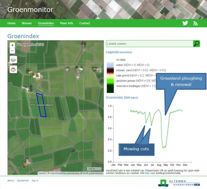
There is a clear connection between cropland/grassland management and carbon sequestration. Phenomena like winter catch crop, green coverage, crop emergence, harvest, grass mowing and ploughing have a significant impact on the carbon emissions and can be derived from remote sensing datasets.
Carbon balance models for cropland and grassland try to calculate the C budget per year from C growth (NPP), C harvested (yield) and other C inputs (cover crop, residue, fertilizer). So far, these models work at regional level with main inputs from meteo and farm statistics data.
However, at field level many of these input variables can be replaced by remote sensing derived farm management indicators, which are just mentioned before.
The objective is to use an existing soil carbon balance model (called RothC), adjust it for implementation at parcel level and enrich the model with satellite derived farm management information.
The pilot area is a subset of parcels in the Netherlands where the soil organic carbon is measured, so the model results can be validated. The farm management information is derived from the Dutch Green Monitor.

Relevance to research/projects at GRS or other groups
ESA funded project called Earth Observation framework for carbon
sequestration monitoring (EO4CSM)
Objectives and Research questions
- What changes in agricultural practices are part of the implementation of carbon farming?
- And how can remote sensing monitor these agricultural patterns? How can the carbon balance in cropland and grassland be quantified? What information can remote sensing provide?
Requirements
- Remote sensing (GRS-20306)
- Advanced Earth Observation (GRS-32306)
Literature and information
- https://www.europarl.europa.eu/RegData/etudes/STUD/2021/695482/IPOL_STU(2021)695482_EN.pdf
- Carbon modelling papers
Expected reading list before starting the thesis research
- EO4CSM project proposal
- EEA report “Carbon mapping for agricultural lands based on HR-VPP satellite data”
Theme(s): Sensing & measuring