Student information
MSc thesis topic: Open-World Land Cover Classification
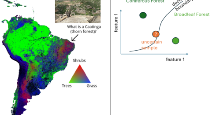
In Land Cover Classification, we represent the richness and heterogeneity of our open world into a (small) set of distinct land cover classes. This Master Thesis investigates methods to go beyond the closed set of a fixed number of classes towards an open-world setting with a variable or open-ended number of categories. One way to address this is quantifying uncertainty through conformal prediction that assigns high uncertainty to data samples that are not represented well in the current categorization (See Fig 2 for mixed forest examples). With this knowledge of uncertainty, we can either choose not to predict this sample and perform selective prediction, or choose a different more general class (hierarchical classification). This thesis can explore both directions and will involve exploring conformal prediction on classical land cover classification methods like random forests and self-supervised deep learning models.
Short data description
- Global land cover fraction data for the year 2015 with sample sites of 100 x 100 m with land cover fractions of nine classes. Training dataset was collected by IIASA and includes over 150 000 sample sites, validation dataset was collected by WUR and includes over 21 000 sample sites.
- Training Points: OpenGeoHub has prepared ~27 million training points from multiple open data sources. These points have a hierarchical land use / land cover legend with matches combinations of LUCAS land cover and land use classes, with 64 classes at the highest level of detail.
- Validation points: For validation, 1.5 million LUCAS points are available, covering large parts of Europe.
Relevance to research/projects at GRS or other groups
- This thesis is jointly supervised by Marc Rußwurm, Dainius Masiliūnas (WU-GRS) and Martijn Witjes from OpenGeoHub. This work is part of an international scientific effort to define the next generation of land cover maps, with a flexible user-oriented legend and a high accuracy per class.
Research Questions & Objectives
- Analyze & compare existing land cover hierarchies and evaluate their applicability and limitations given the provided data.
- Implement an uncertainty-guided method to identify pixels that do not align with existing land cover definitions.
- Develop a methodology to identify a better class label given existing or emerging categorizations or hierarchies.
Potential Output
- Land cover maps with uncertainties at different hierarchy levels and greater thematic detail.
Requirements
- required: Machine Learning course
- required: Geoscripting & Remote Sensing courses
- optional: Deep Learning
Expected reading list before starting the thesis research
- Valle, D., Izbicki, R., & Leite, R. V. (2023). Quantifying uncertainty in land-use land-cover classification using conformal statistics. Remote Sensing of Environment, 295, 113682.
- Angelopoulos, A. N., & Bates, S. (2021). A gentle introduction to conformal prediction and distribution-free uncertainty quantification. arXiv preprint arXiv:2107.07511.
- Masiliūnas, D., Tsendbazar, N. E., Herold, M., Lesiv, M., Buchhorn, M., & Verbesselt, J. (2021). Global land characterisation using land cover fractions at 100 m resolution. Remote Sensing of Environment, 259, 112409.
Theme(s): Modelling & visualisation, Integrated Land Monitoring